 |
| Kotor, Montenegro |
I am an absolute sucker for briefly crossing borders into
nearby countries when I have a small window of opportunity to ‘tick off’
another state. I think it’s the thrill and the novelty of being in a new place,
often with a new language and other distinctions that make it marginally (or
sometimes significantly) different from its neighbours. In this way, I have
visited Monaco, Liechtenstein, San Marino, Mexico and Sweden. In the case of the latter
two, I do plan on returning to see them more thoroughly in the future, but
wasn’t able to at the time. In 2009, I tried unsuccessfully to persuade my
parents to drive across the Croatian border near Plitvice to the Bosnian town
of Bihać for the same purposes. Today was to be another of those occasions.
I am not sure how I first came across Kotor, but when I saw
pictures, I knew I had to go there.
It is similar to Dubrovnik in the sense that it is a historic walled city
belonging to a powerful and important maritime city-state, albeit where Dubrovnik
was the capital of Ragusa, Kotor (Cattaro in Italian) was part of Venice.
Beyond that, they are quite distinct. Dubrovnik’s walled city protrudes into
the sea and is has a reasonably structured layout completely encircled by high
walls. Kotor is a triangle with walls on two sides and is hemmed in by the base
of an enormous mountain on the inland side. Its streets are a maze, each twist
and turn leaving one shaking one’s head at being ejected from the narrow alleys
into a completely different square to the one expected. It was designed this
way deliberately, to confuse would-be invaders, but it seems to have backfired
and apparently even locals struggle to negotiate the old city. Furthermore,
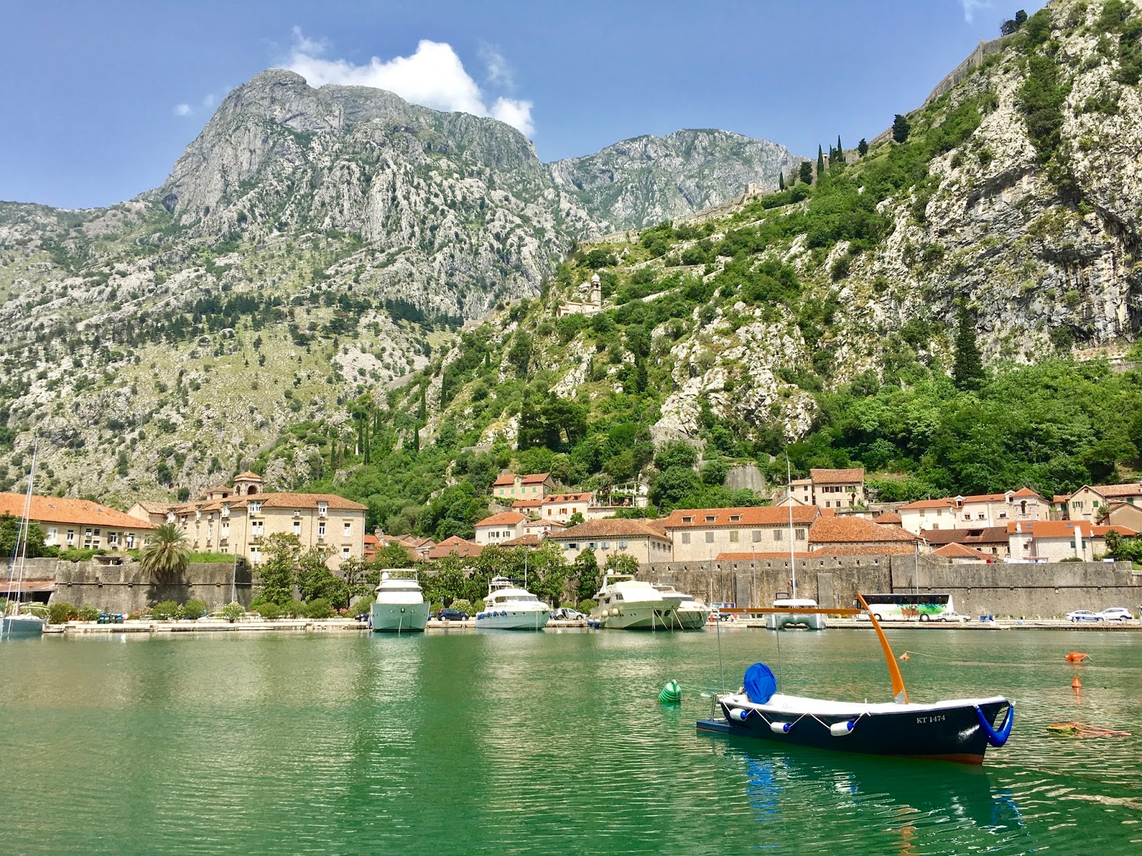
unlike Dubrovnik, Kotor is set back from the coast and is situated within a
deep inlet, the eponymous Bay of Kotor. It is sometimes even considered
Europe’s most southerly fjord, which is technically a misnomer but for literary
purposes, it does quite a good job of describing its remarkable location.
 |
| Mountains border the Bay of Kotor on all sides |
 |
| Small villages dot the boundary between land and sea |
 |
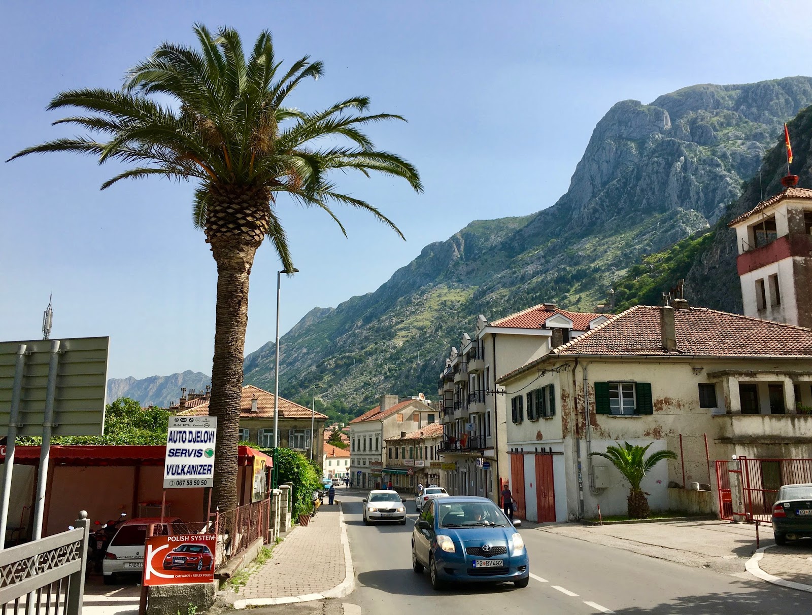
| The road into Kotor, between the bus station and the walled city |
I woke up at 0600 and slipped out of the guest house –
Andrew wasn’t joining me today – and headed down to Dubrovnik’s bus station. I
left at 0700 and an hour later crossed into Montenegro, following a road that
was obscured from the sea by a ridge to the right and traced a small river down
to the entrance of the bay. This was all part of the disputed, formerly
Bosnian, territory of Sutorina. Kotor was now just 15 miles away as the crow
flies, but it took another hour to trace the shoreline of the bulbous bay, a
beautiful but slow-going route from the town of Herceg Novi through a series of
villages. All along this road were advertisements for holiday resorts and
casinos, and it seemed Montenegro has a healthy gambling industry, possibly
explaining why it was used in lieu of northern France as the setting for the
pivotal scenes in Casino Royale,
released in 2006, the year of the country’s independence from Serbia.
The bus stopped in Kotor at 0900 and I decided to take
advantage of the bus station’s facilities before heading off. Having had only
sublime views of the country’s rocky mountains and Kotor’s lovely bay, my
initial impression once off the bus was much less welcome. The lavatory in the
bus station had no light, seat, flush or lock, and cost 50 euro cents to enter.
I beat a sensible retreat and headed for the old city.
 |
| The outer walls of the city's historic core are partially surrounded by a moat |
 |
| Kotor's narrow streets close to the stairs leading to the fortifications |
 |
| The view of the town and its bay from the bottom of the fortifications is already spectacular |
 |
| The stairs close to the base of the fortifications |
 |
| In places, the stairs give way to a stony path |
 |
| The views changed constantly throughout the ascent |
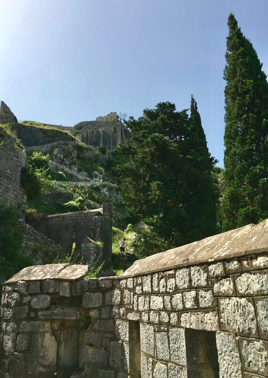
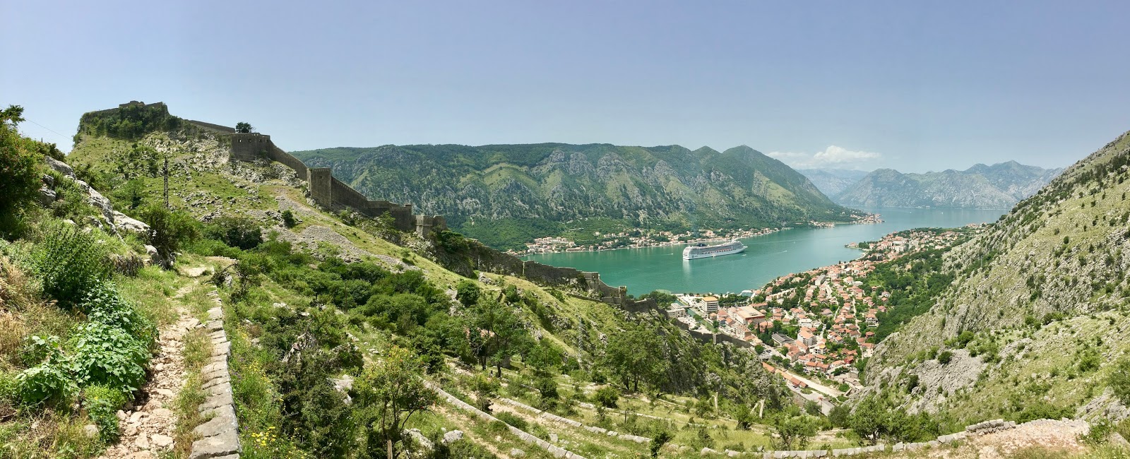
The most notable attraction of Kotor is its system of
fortifications, which rise sharply and dramatically above the clusters of roofs
in the town. As this was the major sight and as the sun can easily heat the
exposed walls to over 30˚C later in the day, I decided to do this first. At
0930 it was comfortably warm at sea level, and would be scorching in a few
hours’ time. Keeping the mountain on my right, I soon found the entrance to the
city’s walls. Ascending the base of the steps, I saw a sign ahead stating that
I had to pay €2 for access. The adjacent room, obviously a ticket office,
turned out not to be a ticket office and the man inside, who apparently had
nothing to do with the fortress, pointed me in the direction of a group of men
sitting huddled over a plastic table in the square, smoking, drinking coffee
and playing cards. Seeing me in my shorts and sunglasses and looking at him
expectantly, one of the men’s tourist radar activated and he approached, and
returned merrily to his game once I had handed him his coin. I later discovered
on my way down that the whole system of walls can be accessed for free by
following a discreet trail from the northern edge of the old town up the lower
slopes of the mountain, and then in through a wide opening at the top, from
where it is possible to see all the views coming down instead of climbing up.
Kotor’s old walls are reminiscent of The Lord of the Rings in a couple of ways. For one thing, although
they are considerably starker and less developed than depicted in the 2003
film, the concept of an extended defensive structure towering upwards over its
centre is rather like the city of Minas Tirith. Secondly, the long and stepped
stone path upwards is akin to the Stairs of Cirith Ungol, the secret passage
that the deceitful Gollum leads protagonists Frodo and Sam up towards the end
of their journey into Mordor. In places, the pathways widened, narrowed again,
widened to allow a church or other stone structure to sit in a small flat
terrace, and then became another steep flight disappearing upwards. 100 metres
up, the Church of Our Lady of Remedy (Crkva
Gospe od Zdravlja), built in 1518, sits perched atop the remains of
Montenegro’s oldest building.
 |
| The Church of Our Lady of Remedy (Crkva Gospe od Zdravlja) commands a fantastic view of the bay |
 |
| Stone steps wind back and forth across the mountainside |
 |
| The ever-diminishing walled city is visibly triangular when seen from above |
 |
| Nearing the summit, with the Fortress of St John a short distance above |
I had noticed a large vessel anchored in the bay, and it appeared that a
significant number of my fellow visitors to the fortifications had come ashore
from the cruise ship. I presume their itinerary included various stops in Croatia, and
perhaps also Italy and Greece, and at each port, they were guided to the shore
and given pointers towards the most important sights to see. Those climbing the
walls were mostly Americans, although I also heard some Italians, and it is
quite possible that those were just the most vocal of the tourist nationalities.
I admired the group’s sense of optimism, but as I made my way ever higher,
there was a tiered effect, with the lowest paths littered with the panting
forms of the most unfit and infirm, gradually thinning to make way for more
athletic people and those who knew what they were in for. There were in fact
plenty of people decades older than me who had made it to the top, but I
observed that they were typically wearing walking boots or using hiking poles,
unlike those in sandals who had given up partway.
The high point of the fortification system is the Fortress
of St John, just shy of 300 metres above Kotor itself. From here, the views
were wonderful, with the houses that line the bay tiny specks, and even the
massive cruise ship dwarfed by the huge peaks on every side of the water. Aside
from the modernity of some of the buildings in the city, and the ship, the view
couldn’t have changed significantly in hundreds of years, during which time
these walls had changed hands from the Byzantines to the Venetians, the
Ottomans, the Italians, the French, and the Austrians, before being part of
Yugoslavia either side of occupation by Nazi Germany. Most of these transfers
were by treaties, but the fortress has been successfully besieged and breached
too. Its biggest threat, though, is nature itself. Various earthquakes have
afflicted the region, most recently in 1979 when many of Montenegro’s most
culturally important sites were badly damaged. Kotor is one of two UNESCO World
Heritage Sites in the country, and was initially placed on the list of
endangered sites during efforts to repair its fortifications.
 |
| Several ruined buildings are found at the summit of the fortifications |
 |
| Traces of the abandoned village of Špiljari are seen at the base of a zigzagging pathway up the mountain behind the fortress |
 |
| The fortification walls climb this rocky outcrop at a sharp angle |
 |
| Peering over the edge reveals a sinuous pathway leading up, and the walled city far below |
It took me around fifty minutes to make the climb from the
base to the Fortress of St John, and after catching my breath and sufficiently
admiring the marvellous views, I started to descend. It was now getting
uncomfortably warm to be out in the sun, and I was glad to be heading towards
the shady streets below. As I went, I poked my nose into a few offshoots of the
main route that I hadn’t seen on my way up, usually just old stone buildings or
small ledges with viewpoints to the mountains or the bay. One of these,
however, had a window that was easily wide enough for a person to fit through,
and it led to a rough trail over scrubby ground towards a little church tucked
behind the outcrop on which the highest levels of the fortifications sit.
Behind, I could see a further trail zigzagging upwards in an endless series of
switchbacks, offering potentially even greater views than before. I here
abandoned my plans to return to sea level in favour of exploring, although this
would mean another hour of hard, relentless climbing by the looks of it.
A nearby middle-aged American couple from the cruise ship
were also entertaining the idea. The woman wasn’t so sure, and declared that
she would sit by the window and wait for her husband. He took a long swig of
the can of lager in his hand, adding further to his prominent beer belly,
adjusted his John Deere baseball cap, and boldly announced that he would
conquer the mountain. Edmund Hillary set off close behind me, but soon lagged
significantly, and I lost sight of him for good five minutes into my hike.
Since the round trip up and back took me two hours, I estimate that he
would have taken three or four, although I sincerely doubt he made it more than
another hundred metres up. I have visions of his loyal wife still sitting
patiently by the window of the fortress like the vigilant widow of an old
mariner lost at sea, anticipating his eventual return.
 |
| The Fortress of St John seen from below |
 |
| The abandoned church of Špiljari |
 |
| The church's interior must once have been elegantly decorated |
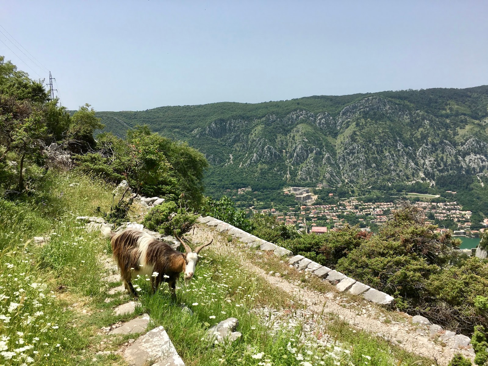
Wedged between the fortifications and the mountain was a
quaint little stone church, nothing inside but flecks of old paint and what may
once have been a tiny altar. The mountain was home to a village called
Špiljari, now abandoned and destroyed, and this church may once have been central
to a small and relatively isolated community living up here. Pushing on, I no
longer had the luxury of stone walls and the shadows they cast, and was out on
the sunbaked flanks of the mountain, mustering all my energy for a punishing
slog. Each hairpin bend became my goal, and I lost count of the number of times
I traversed the slope as I toiled inexorably upwards. I was dripping with sweat
now, and trying to ration the contents of my water bottle to ensure I had
enough to last me back down to the town far below. I kept my eyes peeled for
snakes, as I had no intention of being bitten, but the only life I saw was in
the shape of a few hardy goats, who happily scrambled up and down
clusters of boulders as I meandered back and forth around their vertiginous
playgrounds.
 |
| The path up the mountain was a rugged and slightly overgrown stony trail |
 |
| Water is precious on these slopes, especially in the 30˚C temperatures |
 |
| Goats are perfectly at home on these slopes |
 |
| The switchbacks cut neatly and evenly across the mountainside |
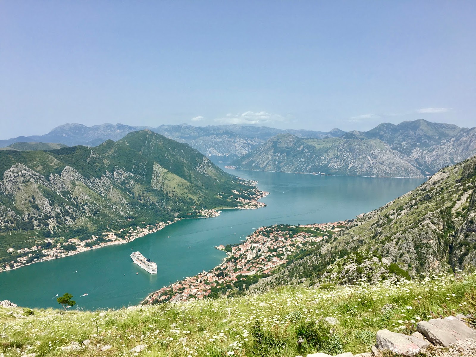
It was utterly exhausting, but so worth it. At the top, I
batted away the microscopic flies that decided my perspiring brow was a
succulent meal for them, and caught my breath in a small grove of trees on the
plateau. Much higher mountains still rose all around me, and my route continued
on towards a lofty pass, eventually to emerge in the national park of Lovćen.
These mountains were inspiring, and in cooler weather, probably in April or
October, would be incredible for hiking and camping. The Bosnian mountains had
similarly caught my attention but the danger of landmines is an obvious
deterrent. Today, though, I had no time to push on even further upwards, nor
did I have much food or water left, never having intended to reach this far up.
Besides, I had achieved the goal I had set for myself when looking out from the
fortifications.
Seen from over 600 metres up, Kotor was a minute wedge of
brown and orange, and the bay contained only white dots where before were
sizeable boats. The mountains that cut Kotor off from the more westerly arm of
the bay were now low enough that I could see higher peaks beyond. I could see
the sea, which is impossible further down because the bay is completely
encircled by mountains. Some distance out, there was some sort of mirage
effect, a low green-grey haze appearing to be another piece of land beyond the
shores of Montenegro. However, unlike Croatia, Montenegro has no large islands
and the nearest land in that direction was the heel of Italy’s boot, 120 miles
across the Adriatic, definitely much too far away to be visible from here.
 |
| Kotor's newer developments sit at the southern edge of the bay, and the sea and further peninsulas are visible beyond |
 |
| The view from the mountain was well worth the arduous grind to get up there |
 |
| There was a near-vertical drop close to the summit |
 |
| A happy hiker! |
I sat in absolute peace at this false summit of the much
higher peak behind me and took in this majestic scene, a spectacle of nature,
complemented by the manmade fortifications, an impressive decoration on one
rocky pinnacle but paling into insignificance by the scale of the giant natural
fortifications around it. I had been utterly alone on the way up, and went on
to pass only one or two fellow hikers on the descent. Everyone else was in the
fortress system.
Noticing an alternate path down, and enjoying following my
instincts, I continued down by this route rather than re-entering the
fortifications at the window. In this way, I discovered that I could have seen
everything so far without having paid the €2. It’s a lesson for the next visit.
I emerged at the bottom of a further series of switchbacks beside the small
Scurda river, and after rounding a corner, I crossed a low bridge and entered
through the city’s northern gate.
 |
| Part of the way down, the angle at which the fortifications' walls rise is clearly visible |
 |
| The little river Scurda melds with the moat at the base of the old city walls; the fortifications can be seen rising up the mountain behind |
As mentioned already, Kotor’s old town is a labyrinth. It
isn’t hugely extensive so I was able to cover almost all its narrow streets,
and saw a few neat churches. One of these was adorned with the flag of the
Serbian Orthodox Church, indicating that I had crossed a divide along the short
journey from Catholic Croatia this morning. This was not as lavishly painted as
Orthodox churches tend to be, but had an ornate iconostasis – a screen
separating the holiest part of the church, where the altar is and which only
priests may access, from the nave – decorated with the images of saints. There
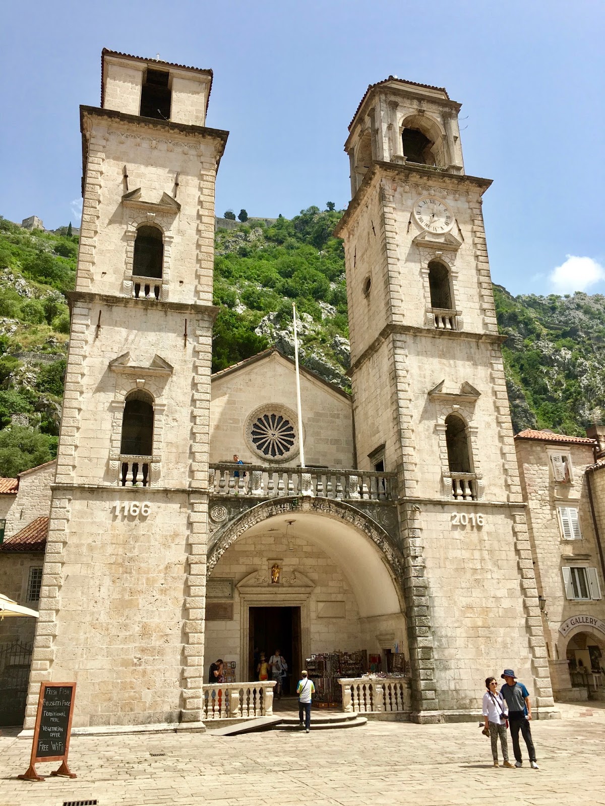
is, however, also a Catholic church in Kotor, the Cathedral of St Tryphon (Katedrala Svetog Tripuna),
which is commemorating its 850th anniversary this year.
 |
| The Serbian Orthodox Church of St Nicholas (Crkva Svetog Nikole) |
 |
| St Nicholas' interior |
 |
| Kotor's old town is full of small squares; on this one is the Church of St Luke (Crkva Svetog Luke) |
 |
| Another small square in Kotor's old town |
 |
| Narrow lanes lead to dead ends filled with rustic dwellings |
 |
| The Cathedral of St Tryphon (Katedrala Svetog Tripuna), celebrating its 850th anniversary |
 |
| Luxury yachts look much bigger from here than from the mountain |
 |
| The Montenegrin mountains dwarf the city and its harbour |
 |
| Local children enjoy leaping from this jetty into the bay, in the shadow of the mountains |
After a thorough exploration of the old town’s streets, I
made the short journey back to the bus station and on the way back to
Dubrovnik, dozed off in the soporific sun. Andrew sent a message explaining
that he had found a better beach than yesterday’s, so I headed off to meet him.
This one, Lapad, was in a wide cove between twin headlands of a peninsula
extending from the west of the city. I immediately took a dip in the mild
waters, which left me feeling thoroughly cleansed after sweating so much during
my sweltering walk up the mountain in Montenegro. When I had come out, Andrew
told me a little of his day. Our host had had to evict us from our room in the
morning because we needed an extra night and she didn’t have space. Instead,
she had arranged for us to take a room in a friend’s house a few minutes down
the road, and he had then whiled away a few hours relaxing in their company
before heading to the beach.
 |
| Sveti Vlaho (St Blaise), 'the first battleship of the Croatian Navy Task Force Dubrovnik, the symbol of resistance during the aggression of Serbia and Montenegro on our town'; this is a reference to the eight-month siege of Dubrovnik in 1991-1992, in which this vessel was sunk whilst serving as a blockade runner |
Neither of us wanting to walk further than necessary, we chose
to eat at the family-run restaurant overlooking the beach, which seemed like a
good idea until the wrong orders were delivered. This would have been
forgivable but we were almost the only people eating there, apart from a
Portuguese woman and her Australian fiancé at the adjacent table, so the excuse
of being overworked could not be used. Neither could our meal have been
described as anything better than ‘generic’; it wasn’t the worst meal I’ve ever
eaten but it wasn’t commendable. Following this disappointing end to our stay
in Dubrovnik, Andrew led the way to our new overnight lodgings. As we walked,
we commented upon the city’s extremely large feline population. Far more than
anywhere else I can remember, Dubrovnik’s neighbourhoods are bursting with cats,
and on every street we saw cats meowing, licking themselves contentedly,
resting upon stone ledges, or softly prowling through the night. In contrast,
the house we were bound for owned a dog (named Titus), a powerful beast of a hound who stood
sentinel on the outdoor patio. Andrew explained that he had a track record of
attacking intruders, but had no ability to discriminate between burglars and
legitimate visitors to the house. Thankfully, he had met Andrew earlier in the
day and allowed us in, though he was clearly sceptical of our right to be
there. Inside, we went over the plan for the morning – a bus back north to
Split, sightseeing there, and then the overnight ferry to Ancona in Italy – and
then I fell sound asleep.
 |
| Dubrovnik's swansong was this blaze of fire across the summer sky as the sun set |


No comments:
Post a Comment